To view a larger image, please click here or hover over the photo above.
Author: Blaeu
Year/Period: 1669
| Size: | Inches: | 67 x 51 |
| CM: | 170 X 130 |
Price: $2,649.99
SKU: CONT 18
Description:
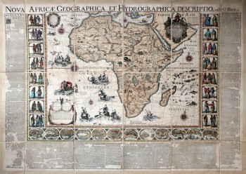
The Blaeu family ran one of the most renowned Dutch publishing house during the seventeenth century, specialised in the printing of geographical books, nautical maps and atlases.The Blaeu printing works are especially known for the publication in 1669 of four large mural maps representing Europe, the Americas, Asia and Africa.They were exquisitely made and exceptionally beautiful, and are distinguished by the richness of the scrolls and the detail in their engraving. Each map is approximately 67X51 inches and was produced using the same techniques and style, giving a unique theme to the collection. At each side of the map there are eight engravings, representing sixteen people from the local population illustrated on the map. The Southern section contains twelve views of cities and places of the region depicted and, finally, the outside of the frame has a geographic description of the depicted continent in both French and Latin. There are human and fauna figures interspersed between the geographic details covering the continents which lends a certain liveliness to the planemetry. The expanses of the oceans have repeated the usual themes of marine gods, bizarre fish and adventurous vessels. All of this comes together as an eloquent decorative whole, transforming these four maps into true masterpieces of both historic and artistic significance.
Engraving Information:
This artistic reproduction of an antique map was made using the same techniques, materials and instruments used for the original. Map is created from a zinc slab that is mounted on a wooden base and printed by hand, a piece at the time, on a press with a limited production size of 20 pieces each time. Map is printed on cotton-paper panels which are glued and mounted on a cotton cloth background "a stacchi" (slightly separated from each other), in order to allow for folding and easier transport. Finally, map is water-colored by hand, making it a truly unique piece, worthy of the original vintage map.Useful Links (provided by Wikipedia):
Useful Link 1


