To view a larger image, please click here or hover over the photo above.
Author: Ortelius
Year/Period: 1590
| Size: | Inches: | 32 x 24 |
| CM: | 75 x 60 |
Price: $829.99
SKU:
Other Images:
Description:
N.B. : EVEN THOUGH YOU CAN SEE ON OUR WEB SITE SOME OF THE MAPS/ PICTURES SHOWN IN B/W KEEP IN MIND THAT ALL OF THEM AS FINAL STEP OF THE ARTISTIC PROCESS WILL BE ALWAYS COMPLETELY WATER COLORED BY HAND.
We suggest you to take a look at the artistic process shown step by step on the left side or by clicking on the link available on the right side you can see the video showing the entire artistic process.
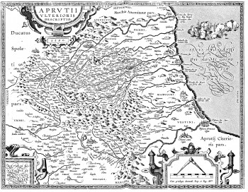
Abruzzo Ulterioris (latin) or Ultra with seat to Aquila was located to the north of Pescara river and the borders of "the giustizierato" embraced totally the areas of today’s provinces of Aquila, Teramo, most part within the present Provinces of Pescara and the North East side of the province of Rieti nowadays belonging to the Latium region.
The borders of all the Abruzzo Ulterioris were surrounded from north the north east by the course of the Tronto river,in the north east by the mountains chain of the Gran Sasso. in the south by course of the Pescara river,
Abraham Ortelius (Antwerp 1527-1598) was a Flemish cartographer and geographer, generally recognised as the creator of the first modern atlas, the Theatrum Orbis Terrarum (Theatre of the World) which was published in forty-two editions in seven languages from 1570 to 1612. He is also believed to be the first person to imagine that the continents were joined together before drifting to their present positions. He came to be recognized by his contemporaries as the "Ptolemy of the 16th century".
Engraving Information:
This artistic reproduction of a vintage map was made using modern graphic procedures, but obtaining the results found in the antique copperplate engraving technique, as one can easily find out by lightly rubbing his/her finger on the map. This map, which is an exact reproduction of the original antique, is printed on cotton paper panels which are glued and mounted on a cotton cloth background "a stacchi" (slightly separated from each other), in order to allow for folding and easier transport. Finally, map is water-colored by hand making it a truly unique piece, worthy of the original old print.
Useful Links (provided by Wikipedia):
Useful Link 1


