To view a larger image, please click here or hover over the photo above.
Author: F. De Wit
Year/Period: 1688
| Size: | Inches: | 63 x 35 |
| CM: | 160 x 90 |
Price: $1,599.99
SKU:
Other Images:
Description:
we remind you to refer to the artistic process shown on the left side
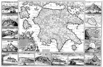
This late-17th century map by the Dutch engraver, publisher, and map seller Frederick de Wit (1629 or 1630-1706) shows the Peloponnesian Peninsula of Greece. The outer margins contain views of 14 fortified towns, the names of which are given in Italian. The illustration at the lower left shows a lion with enslaved human figures in an embellished cartouche with title. At the time the map was made, Greece was under the rule of the Ottoman Empire. The Ottomans allowed religious freedom to the Christians of Greece, but not full equality or political rights. De Wit was born in Gouda and moved to Amsterdam, where he maintained his shop on the Kalverstraat. His works included sea and world atlases, wall maps, and town books containing plans of Dutch and European cities. Some time after 1674 he acquired the copper plates of town books by Jansonnius and Blaeu. In 1688, he obtained from the States General, the Dutch government of the day, the privilege to publish his maps. De Wit’s maps were in demand throughout Europe and were sold until 1763 by the firm of Johannes Covens and Corneille Mortier.
Cephalonia Island (Greece); Kythēra Island (Greece); Lefkas Island (Greece); Peloponnesus (Greece); Zakynthos (Greece: Nome)
Engraving Information:
This artistic reproduction of a vintage map was made using modern graphic procedures, but obtaining the results found in the antique copperplate engraving technique, as one can easily find out by lightly rubbing his/her finger on the map. This map, which is an exact reproduction of the original antique, is printed on cotton paper panels which are glued and mounted on a cotton cloth background "a stacchi" (slightly separated from each other), in order to allow for folding and easier transport. Finally, map is water-colored by hand making it a truly unique piece, worthy of the original old print.
Useful Links (provided by Wikipedia):
Useful Link 1


