To view a larger image, please click here or hover over the photo above.
Author: van der Aa
Year/Period: 1700 ca.
| Size: | Inches: | 32 x 24 |
| CM: | 80 x 60 |
Price: $559.99
SKU:
Description:
We remind you to refer to the artistic process shown on the left side or see the video available on the right side referring to the artistic process.
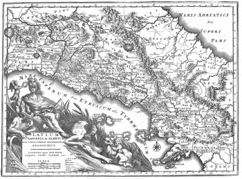
This interesting map made by the Dutch cartographer P. Van der Aa operating between the 17th and 18th century display us a beautiful cartouche on the left side who embraced a wide macro area with more than 4 Southern Italian regions :Latium, Campania, Abruzzi and Molise . As you can assume from the title of the map, Latium Campania, and Sannium (nowadays province of Benevento and neighbouring areas) have a wide and prominent topographical description as you can see.Moreover are displayed part of the bordering areas nowadays Italian regions like Marche Abruzzi and Molise.
Engraving Information:
This artistic reproduction of a vintage map was made using modern graphic procedures, but obtaining the results found in the antique copperplate engraving technique, as one can easily find out by lightly rubbing his/her finger on the map. This map, which is an exact reproduction of the original antique, is printed on cotton paper panels which are glued and mounted on a cotton cloth background "a stacchi" (slightly separated from each other), in order to allow for folding and easier transport. Finally, map is water-colored by hand making it a truly unique piece, worthy of the original old print.


