To view a larger image, please click here or hover over the photo above.
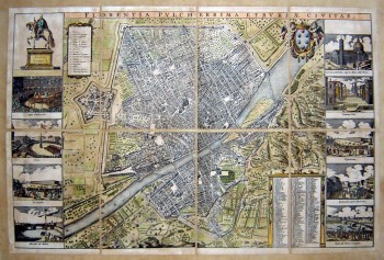
Florentia Pulcherrima Etruriae Civitas . (Big version)
Author: F. de wit
Year/Period: 1600's
| Size: | Inches: | 78 x 67 |
| CM: | 200 x 175 |
Price: $2,149.99
SKU: PIA 31/A
Description:
Frederik de Wit (1616-1698) was a famous Dutch publisher of maps and atlas. He is particularly well known for his wall maps, of which NOVA TOTIUS TERRARUM ORBIS TABULA (1670) is one of the finest examples. This map of the city of Florence, Florentia Pulcherimma Etruriae Civitas, is characterized by several insets on both sides showing the major points of interest and monuments. The legend at the bottom right provides precise numerical reference to the major points of interest and monuments.
Engraving Information:
This artistic reproduction of an antique map was made using the same techniques, materials and instruments used for the original. Map is created from a zinc slab that is mounted on a wooden base and printed by hand, a piece at the time, on a press with a limited production size of 20 pieces each time. Map is printed on cotton-paper panels which are glued and mounted on a cotton cloth background "a stacchi" (slightly separated from each other), in order to allow for folding and easier transport. Finally, map is water-colored by hand, making it a truly unique piece, worthy of the original vintage map.Useful Links (provided by Wikipedia):
Useful Link 1


