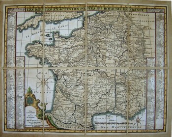
To view a larger image, please click here or hover over the photo above.
Author: Lotter
Year/Period: 1700's
| Size: | Inches: | 23 x 18 |
| CM: | 59 X 46 |
Price: $359.99
SKU: EUR 1
Description:
Tobias Conrad Lotter (1717-1777), was a German master engraver and one of the most prominent cartographers of his day. He was the son in law of Georg Mattheus Seutter (1647-1756), himself one of the most important and prolific German map publishers of the 18th century. Upon Seutter’s retirement Lotter took control of the firm and republished many of his maps with minor updated and changes. In time, Lotter became one of the most prominent mid 18th century map publishers working in the German school. After his death in 1777, the firm was taken over by his son, Mathias Albrecht Lotter who republished and updated many of his father’s maps.This map of France is characterized by a strong outline and extensive legends detailing all the major French cities.
Engraving Information:
This artistic reproduction of an antique map was made using the same techniques, materials and instruments used for the original. Map is created from a zinc slab that is mounted on a wooden base and printed by hand, a piece at the time, on a press with a limited production size of 20 pieces each time. Map is printed on cotton-paper panels which are glued and mounted on a cotton cloth background "a stacchi" (slightly separated from each other), in order to allow for folding and easier transport. Finally, map is water-colored by hand, making it a truly unique piece, worthy of the original vintage map.


