To view a larger image, please click here or hover over the photo above.
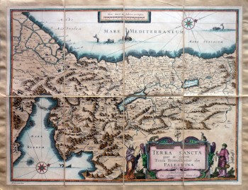
Terra Sancta quae in Sacris Terra Promissionis olim Palestina
Author: Willem Blaeu
Year/Period: 1630
| Size: | Inches: | 29 x 22 |
| CM: | 75 x 55 |
SKU:
Other Images:
Description:
We remind you to refer to the artistic process shown on the left side or see the video available on the right side referring to the artistic process.
The Blaue family ran one of the most renowned Dutch publishing house during the seventeenth century, specialized in the printing of geographical books, nautical maps and atlases. Willem and his son Joan published the Atlas Novus (full title: Theatrum orbis terrarum, sive, Atlas novus) in two volumes in 1635. Joan and his brother Cornelius took over the studio after their father died in 1638. Joan became the official cartographer of the Dutch East India Company.
This coloured map of Palestine (full title "Terra Sancta quae in Sacris Terra Promissionis olim Palestina"), is oriented to the west and shows the Holy Land on both sides of the Jordan from Tripoli to the Nile Delta. Moses receiving the Ten Commandments and Aaron are illustrated on either side of the title cartouche and Pharoah’s forces are shown drowning in the Red Sea. Originally engraved by J. Hondius, Jr., the map was first published by Blaeu in 1630 and appeared in all editions of his Atlas Novus.
Engraving Information:
This artistic reproduction of a vintage map was made using modern graphic procedures, but obtaining the results found in the antique copperplate engraving technique, as one can easily find out by lightly rubbing his/her finger on the map. This map, which is an exact reproduction of the original antique, is printed on cotton paper panels which are glued and mounted on a cotton cloth background "a stacchi" (slightly separated from each other), in order to allow for folding and easier transport. Finally, map is water-colored by hand making it a truly unique piece, worthy of the original old print.


