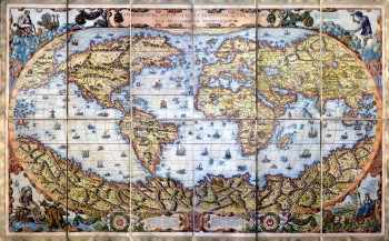
To view a larger image, please click here or hover over the photo above.
Author: Camocio
Year/Period: 1560
| Size: | Inches: | 66 x 35 |
| CM: | 141 x 87 |
Price: $1,399.99
SKU: PLA. 50
Other Images:
Description:
Giovanni Francesco Camocio (fl.1550?-c.1575) published in the early 1560s a number of maps that were drawn by Forlani, including maps of the World, North Atlantic, Africa, France, Switzerland, and provinces of the Low Countries.
Around 1570, Camocio published an Isolario, or collection of maps of islands, principally from the Mediterranean, but including the British Isles and Iceland. Camocio's earliest issues lacked a title-page, and tended to be a relatively random selection from the available stock.
Later he added a title Isole Famose Porti, Fortezze E Terre Maritime. After his death, which is assumed to have been in 1575, the plates were reprinted, with a title-page bearing the Bertelli family address 'alla Libraria del Segno di S. Marco', possibly by Donato Bertelli, whose imprint is found on a later state of Camocio's world map of 1560.
Engraving Information:
This artistic reproduction of a vintage map was made using modern graphic procedures, but obtaining the results found in the antique copperplate engraving technique, as one can easily find out by lightly rubbing his/her finger on the map. This map, which is an exact reproduction of the original antique, is printed on cotton paper panels which are glued and mounted on a cotton cloth background "a stacchi" (slightly separated from each other), in order to allow for folding and easier transport. Finally, map is water-colored by hand making it a truly unique piece, worthy of the original old print.


