


To view a larger image, please click here or hover over the photo above.
Author: Waldseemuller
Year/Period: 1507
| Size: | Inches: | 83 x 51 |
| CM: | 210 x 130 |
Price: $2,599.99
SKU: PLAN 34/A
Other Images:
Description:
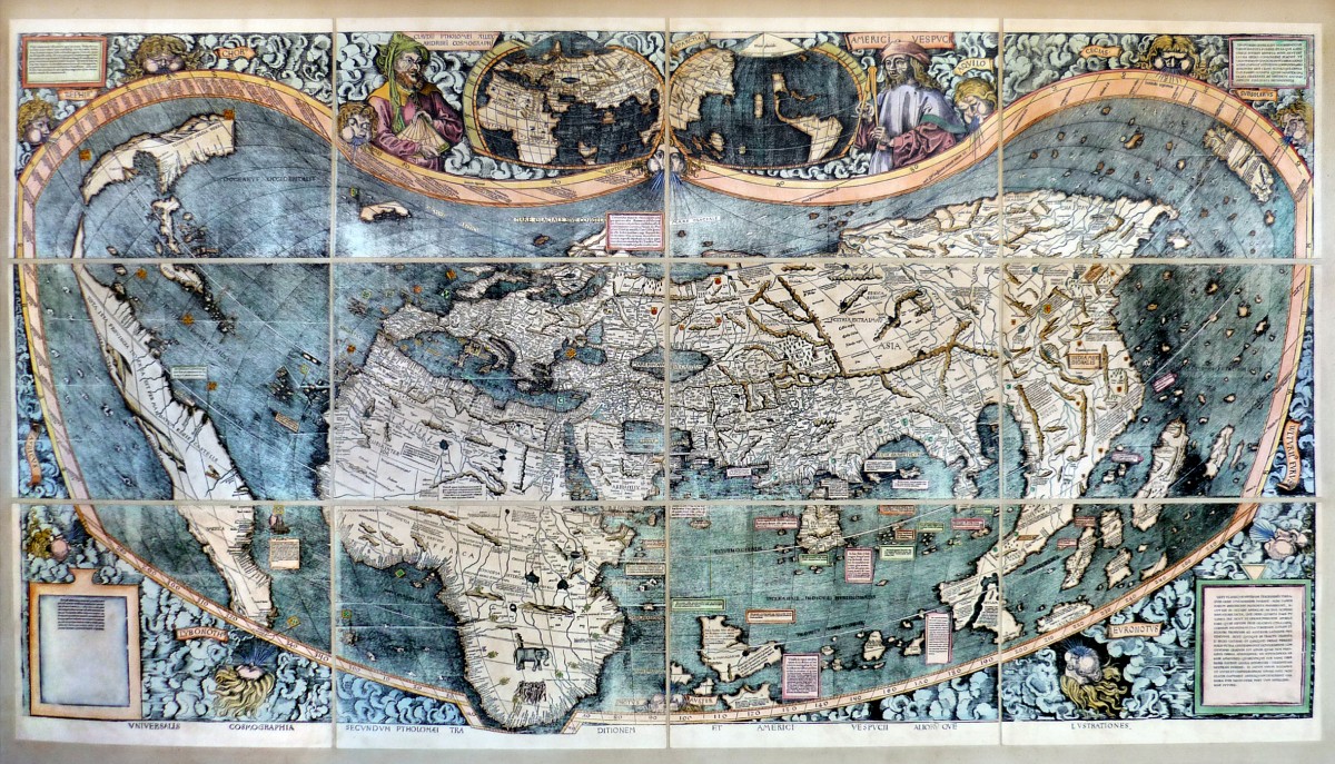
"AMERICA'S BIRTH CERTIFICATE"
Martin Waldseemüller (Latinized Martinus Ilacomylus, Ilacomilus or Hylacomylus) 1470-1520, was a German cartographer. He and Matthias Ringmann are credited with the first recorded usage of the word America in honor of the Florentine explorer Amerigo Vespucci. On April 25, 1507, as a member of the Gymnasium Vosagense at Saint Diey (in the duchy of Lorraine) he produced a globular world map and a large 12-panel world wall map (Universalis Cosmographia), both bearing the first use of the name "America" and showing the New Continent as separate and distinct from Asia.. The globular and wall maps were accompanied by a book Cosmographiae Introductio, an introduction to cosmography. The map uses a modified Ptolemaic map projection with curved meridians to depict the entire surface of the Earth. While some maps after 1500 show, with ambiguity, an eastern coastline for Asia distinct from the Americas, the Walseemuller map apparently indicates the existence of a new ocean between the trans Atlantic region of the Spanish discoveries and the Asia of Ptolemy and Marco Polo. The fist historical records of Europeans to set eyes on this ocean, the Pacific, are recorded by Vasco Nunez de Balboa in 1513 or, Ponce de Leon in 1512 or 1513. Those dates are five to six years after Walseemuller made his map. The Walseemuller world map depicts the American continents in two pieces. The name for the northern land mass, Parias, is derived from a passage in the Four Voyages of Amerigo Vespucci, in which, after several stops, the expedition arrives at a region that was "situated in the torrid zone directly under the parallel which describes the Tropic of Cancer. And this province is called by inhabitants Parias". The name America is placed on what is now called South America on the main map: as explained in " Cosmographiae Introdutio", the name was bestowed in honor of Amerigo Vespucci. Images of him and Ptolomy appear on the top of the map. The Waldseemüller wall map was lost for a long time, but a copy was found in a castle at Wolfegg in southern Germany by Joseph Fischer in 1901. Of the one thousand copies of the map that Waldseemuller stated were printed, it is still the only copy known to survive, and it was purchased by the Library of Congress for ten million dollars in May 2001.
Engraving Information:
This artistic reproduction of a vintage map was made using modern graphic procedures, but obtaining the results found in the antique copperplate engraving technique, as one can easily find out by lightly rubbing his/her finger on the map. This map, which is an exact reproduction of the original antique, is printed on cotton paper panels which are glued and mounted on a cotton cloth background "a stacchi" (slightly separated from each other), in order to allow for folding and easier transport. Finally, map is water-colored by hand making it a truly unique piece, worthy of the original old print.


